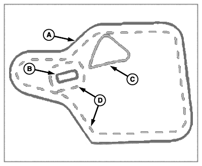
Field Boundaries
PC21838-UN-19NOV15
A - Exterior Boundary (Pink)
B - Interior Impassable Boundary (Pink)
C - Interior Passable Boundary (Yellow)
D - Headland Boundary (Yellow)
The exterior boundary (A) marks the perimeter of a field.
Interior boundaries mark important areas of field. These can either be impassable (pink) (B) or passable (yellow) (C). An example of an impassable boundary is a well, while an example of a passable boundary is a waterway.
Headland boundaries (yellow dashes) (D) mark areas in the field where there are end rows or turn rows. They are created inside the exterior boundary and around impassable interior boundaries.
When used with Section Control, boundaries prevent application of product inside marked areas of the field and outside of the field.
Area Calculation
An estimated boundary area is calculated on a flat two-dimensional plane. All active interior boundary areas are subtracted from exterior boundary area. Elevation changes are not used in boundary area calculation.
Work Totals include elevation changes in area worked totals. Due to calculation differences, boundary and work totals vary.
Creating a boundary requires the following:
- Field name.
- Coverage map with no coverage gaps around the exterior of the field.
|
DX,PC,FIELDS,BOUNDARIES-19-20151222 |