Data Log
PC12574-UN-15APR10
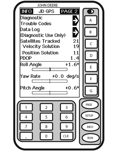
INFO - GPS - PAGE 2
A - Diagnostic Trouble Codes
B - Data Log (Diagnostic Use Only)
C - Satellites Tracked
Velocity Solution
D - Position Solution
PDOP
E - Roll Angle
F - Yaw Rate
G - Pitch Angle
Screen: INFO - GPS - PAGE 2
Press: INFO >> StarFire 3000 >> PAGE
Press letter button next to DATA LOG to access three data log pages. These pages consist of graphs showing GPS information for up to previous 60 minutes. Graphs can be used to show user any variation that has occurred in last 60 minutes.
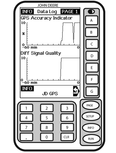
INFO - DATA LOG - PAGE 1
PC12075-UN-13MAY09
INFO - DATA LOG - PAGE 1
A - GPS Accuracy Indicator
B - —
C - GPS Signal Quality
D - Differential Signal Quality
E - —
F - —
G - Return to GPS Info
Screen: INFO - DATA LOG - PAGE 1Press: INFO >> StarFire 3000 >> PAGE >> DATA LOG
GPS Accuracy Indicator: GPS Accuracy Indicator is a relative indication of overall differential GPS performance.
Differential Signal Quality: Differential signal quality is strength of StarFire network signal (SF2 or SF1). Normal range is from 5 to 15, but maximum reading on indicator is 10. Numerical value is displayed to right of indicator. Any value above 5 is normal.
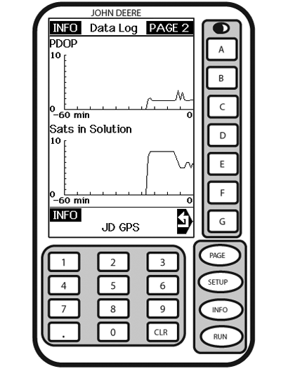
INFO - DATA LOG - PAGE 2
PC12076-UN-13MAY09
INFO - DATA LOG - PAGE 2
A - PDOP
B - —
C - —
D - Satellites Used
E - —
F - —
G - Return to GPS Info
Screen: INFO - DATA LOG - PAGE 2Press: INFO >> StarFire 3000 >> PAGE >> DATA LOG >> PAGE
PDOP: (Position Dilution Of Precision) is a combination of vertical and horizontal error (or three dimensional). Lower PDOP is better. A value below 2 is considered optimal.
Satellites in Solution: Number of satellites that receiver is using in current position solution. Satellites in solution are not tracked until they get above 5 degrees elevation mask.
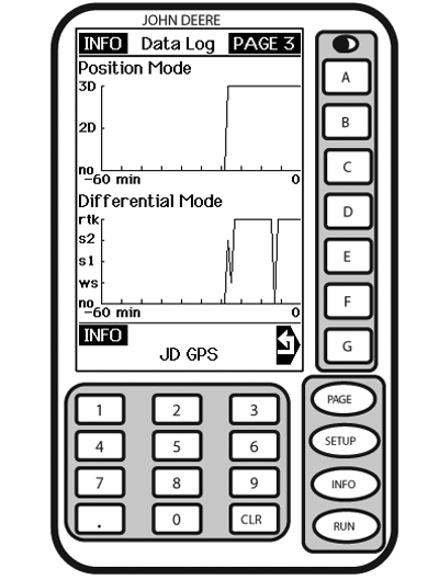
INFO - DATA LOG - PAGE 3
PC12077-UN-13MAY09
INFO - DATA LOG - PAGE 3
A - Position Mode
B - —
C - —
D - Differential Mode
E - —
F - —
G - Return to GPS Info
Screen: INFO - DATA LOG - PAGE 3Press: INFO >> StarFire 3000 >> PAGE >> DATA LOG >> PAGE >> PAGE
Position Mode: Position mode is represented as three different types; No Nav, 2D and 3D. This helps determine if GPS position has been dropped in last 60 minutes.
Differential Mode: This shows level of differential signal that you have been receiving over past 60 minutes. Level of signal that you purchased on your receiver will determine highest point on bar graph that you will see.
- RK - RTK
- S2 - SF2
- S1 - SF1
- WS - WAAS
- NO - none
|
JS56696,0000572-19-20100415 |