INFO - GPS - PAGE 1
PC12073-UN-12MAY09
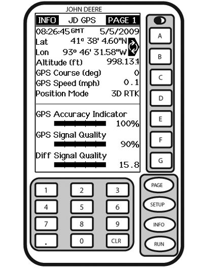
INFO - GPS - PAGE 1
A - Latitude
B - Longitude
Altitude
C - GPS Course
GPS Speed
D - Position Mode
E - GPS Accuracy Indicator
F - GPS Signal Quality
G - Differential Signal Quality
Screen: INFO - GPS - PAGE 1Press: INFO >> StarFire 3000
This screen shows information and status of incoming GPS and differential correction signals. No information on this screen can be changed. It is for viewing only.
Date and Time: This cell shows date and time for Greenwich Mean time.
Lat: This cell displays vehicle location latitude coordinates with respect to Equator (north or south).
Lon: This cell shows vehicle location longitude coordinates with respect to Prime Meridian (east or west).
NOTE: Toggle button allows operator to change the way latitude and longitude are displayed between degrees, minutes, seconds and decimal degrees.
Altitude: This cell shows height of receiver, measured from top of dome, in meters (feet) above sea level.
GPS Course: This cell displays direction of travel, in degrees, relative to true north (zero degrees) as measured by receiver. Angle is measured in clockwise direction.
NOTE: Course and speed normally show small speeds and various courses even when machine is not moving.
GPS Speed: This cell shows ground speed of machine in kilometers per hour (mile per hour) as measured by receiver.
Position Mode: This cell indicates whether receiver is calculating a 3D position, 2D position, or no position (no nav). It also shows status of differential signal: SF 1 (StarFire 1 differential), SF 2 (StarFire 2 differential).
GPS Accuracy Indicator: StarFire 3000 includes GPS Accuracy Indicator (GPS AI). GPS AI gives indication of GPS position accuracy achieved by receiver, and is displayed as a percentage (0-100%). GPS AI is displayed on RUN Page of Parallel Tracking (Figure 1), AutoTrac, and Field Doc and INFO – GPS – Page 1 (Figure 2).
When receiver is initially powered, GPS AI will display 0%. As receiver acquires satellites and calculates a position, GPS AI will increase as accuracy improves. Acceptable guidance performance for Parallel Tracking and AutoTrac is achieved when GPS AI displays 80% or greater. This may take up to 20 minutes. GPS accuracy is affected by many factors. If 80% accuracy or greater is not achieved within 25 minutes, consider following possibilities:
- Unobstructed view of sky – trees, buildings, or other structures may block receiver from receiving signals from all available satellites
- L1/L2 signal to noise ratio (SNR) – radio interference from 2-way radios or other sources may cause low SNR
- Satellite position in sky – poor GPS satellite geometry can reduce accuracy
- Number of satellites above elevation mask – this is total number of GPS satellites available to your receiver that are above 5 degrees elevation mask
- Number of satellites in solution – this is total number of satellites that are being used by receiver to calculate a position
GPS Signal Quality: This cell shows quality of signals being received from constellation of GPS satellites.
Differential Signal Quality: This cell shows quality of differential correction signal being received by receiver.
|
JS56696,0000570-19-20090710 |