Reading Satellite Sky Plot
PC21381-UN-20JUL15
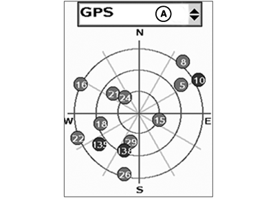
Sky Plot
A - Satellite System Drop-Down Menu
-
Select satellite system from drop-down menu (A).
- GPS–Global positioning system
- GLONASS–Global navigation satellite system
- StarFire™
- Sky Plot is fixed so that North is always at top.
-
Satellites are displayed as their satellite identification (ID)
number that correspond to Satellite Tracking chart.
- Red–Indicates satellite is in search mode.
- Blue–Indicates satellite is being tracked.
- Green–Indicates satellite is being used for corrections.
- Sky Plot consists of three concentric rings depicting 0, 30, and 60 degrees of elevation with directional crossbar intersection representing 90 degrees of elevation.
- Radial lines extending from center of Sky Plot represent azimuth, and are spaced 30 degrees apart.
- Directional crossbar representing North, South, East, and West also represent azimuth at 0, 90, 180, and 270 degrees.
|
StarFire is a trademark of Deere & Company |
HC94949,00007B7-19-20150728 |