System Status-Mobile-RTK
ZX1042317

System Status-Mobile-RTK


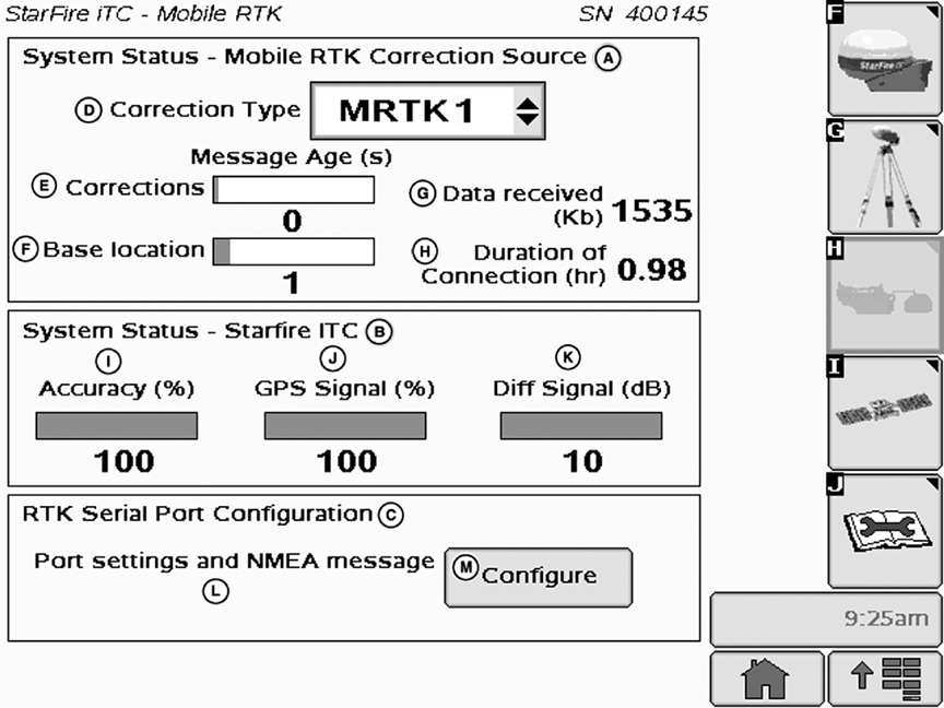
A-System Status - Mobile-RTK Correction Source
B-System Status - StarFire iTC


C-RTK Serial Port Configuration
D-Correction Type
E-Corrections (Message age)
F-Base Location (Message age)


G-Data Received
H-Duration of Connection
I-Accuracy
J-GPS Signal


K-Differential Signal
L- Setting and NMEA message
M-Configure Button

(A) System Status - Mobile-RTK Correction Source

Press: MENU button >> STARFIRE ITC button >> Mobile-RTK softkey >> CORRECTION TYPE drop down box

  • (D) Correction Type:

    Operator must select one Mobile-RTK correction source:

    • MRTK 1 (Default)
    • MRTK 2
    • MRTK 3
    • Off
  • (E) Corrections: Indicates Mobile-RTK correction data stream during MCMA (Maximum Correction Message Age).

OUCC002,0002B80 -19-30JUL09-1/2


    IMPORTANT: Mobile-RTK correction source status bars (E) and (F) displayed in red while StarFire iTC status bars (I), (J) and (K) are displayed in green clearly identifies a StarFire Mobile-RTK failure. In this case, check your settings again (Correction Type (D) and RTK Serial Port Configuration (C)) and contact your John Deere dealer.

    NOTE: Status bars (E) and (F) are green in case of Mobile-RTK correction streaming or red when no Mobile-RTK correction streaming is detected during MCMA.

  • (F) Base Location: Indicates the reception of the next base station reference position data within the provider network.
  • (G) Data Received (kb): Indicates the total of data received. Calculation starts once the connection is accepted and used by StarFire.
  • (H) Duration of Connection (hr): Indicates the duration of connection. Calculation starts once the connection is accepted and used by StarFire.

    NOTE: Data (G) and duration (H) totals do not accumulate if correction messages are not recognized or received for more than MCMA.

(B) System Status - StarFire iTC

Operator can view the following:

NOTE: GPS accuracy (I), GPS signal quality (J) and differential signal quality (K) are also displayed on StarFire iTC main - INFO tab screen (see INFO tab-Mobile-RTK in GS2 Display-StarFire iTC Section).

  • (I) GPS Accuracy Indicator (GPS AI): GPS AI gives indication of GPS position accuracy achieved
    by receiver, and is displayed as a percentage (0-100%)

When receiver is initially powered, GPS AI will display 0%. As receiver acquires satellites and calculates a position, GPS AI will increase as accuracy improves. Acceptable guidance performance for Parallel Tracking and AutoTrac is achieved when GPS AI displays 80% or greater. This may take up to 20 minutes. GPS accuracy is affected by many factors. If 80% accuracy or greater is not achieved within 25 minutes, consider the following possibilities:

  • Unobstructed view of sky › trees, buildings, or other structures may block receiver from receiver signals from all available satellites.
  • L1/L2 signal to noise ratio (SNR) › radio interference from 2-way radios or other sources may cause low SNR (check satellite button I › Graph)
  • Satellite position in sky › poor GPS satellite geometry can reduce accuracy (check satellite button I › SkyPlot)
  • Number of satellites above elevation mask › this is the total number of GPS satellites available to receiver that are above 7 degrees elevation mask (check satellite button I › SkyPlot).
  • Number of satellites in solution › this is total number of satellites that are being used by receiver to calculate a position (check satellite button I › SkyPlot).

  • (J) GPS Signal Quality: Displays quality of signals being received from constellation of GPS satellites.
  • (K) Differential Signal Quality: Displays quality of differential correction signal being received by receiver.

(C) RTK Serial Port Configuration:

Allows the operator to configure the RS232 serial port setting and NMEA message (L). Press Configure button (M) to proceed (see Mobile-RTK Port Configuration Subpage in this Section).

OUCC002,0002B80 -19-30JUL09-2/2